|
 Leatherwood
Ford - 2.3 Leatherwood
Ford - 2.3
Latitude: N 36°28'38"
Longitude: W 84°40'10"
Elevation: 874'
at Leatherwood Ford cross the low wooden bridge near the information gazebo.
After crossing the bridge the John Muir trail follows the Cumberland River down
stream.
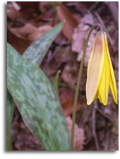
Big South Fork
Wildflowers |


 For
those that plan on leaving a car at the
Southern end of the trail it is recommended you park at
Leatherwood Ford and back track the two miles to the beginning of the
trail because O.W. Bridge is isolated and unlit area.
For
those that plan on leaving a car at the
Southern end of the trail it is recommended you park at
Leatherwood Ford and back track the two miles to the beginning of the
trail because O.W. Bridge is isolated and unlit area.