| A growing collection of maps and GPS waypoints
from in
and around Obed Wild & Scenic River near Wartburg and Crossville, Tennessee. |
|
|
|
Waypoint |
Latitude |
Longitude |
| Adams Bridge |
N36°03.654' |
W084°57.685' |
|
Barnett Bridge |
N36°07.348' |
W084°47.668' |
| Barnett Bridge Rd/Hwy 298 |
N36°06.305' |
W084°47.355' |
|
Barnett Bridge Campsite |
N36°07.335' |
W084°47.503' |
| |
|
|
|
|
|
|
| Barnett's Rib |
N36° 7.123' |
W84°
48.222' |
|
|
|
|
|
Clear Creek Junction |
|
|
|
Climbing Parking² |
N36° 06.075' |
W084° 42.605' |
| Cumberland Trailhead (Nemo) |
N36° 04.247' |
W84° 39.827' |
|
|
|
|
| |
|
|
|
Devils Breakfast Table |
N36° 3.581' |
W84°
47.483' |
| Double Drop Falls |
N36°
7.135' |
W84°
48.345' |
|
Hegler Arches |
N36° 7.186' |
W84°
48.649' |
| Jack's Rock Falls |
N36° 5.888' |
W84° 42.597' |
|
|
|
|
|
Jett Bridge |
N36°07.301' |
W084°44.737' |
|
|
|
|
| |
|
|
|
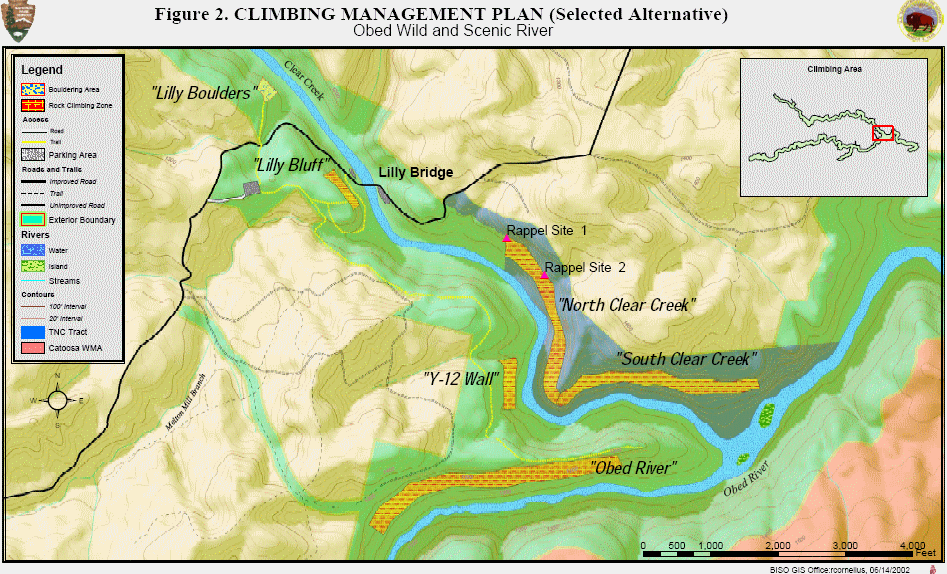
Lilly Bluff |
N36° 06.068' |
W84°
43.062' |
| Lilly Bluff Parking Area |
N36° 06.162' |
W84°
43.280' |
|
Lilly Bouldering Area |
N36° 06.305' |
W84°
43.347' |
| Lilly Bridge |
N36° 06.122' |
W84° 42.983' |
|
Lilly Point Arch |
N36° 5.445' |
W84° 42.387' |
| |
|
|
|
|
|
|
| Melton Mill Br. Falls |
N36° 5.993' |
W84° 43.097' |
|
|
|
|
| |
|
|
|
Nemo Bridge/Picnic Area |
N36° 04.119' |
W84° 39.746' |
|
Nemo Tunnel |
|
|
|
Obed Junction |
|
|
|
Potters Ford |
|
|
|
|
|
|
| Rock Creek Campground |
N36° 04.253' |
W084° 39.874' |
|
U.S. 127 Bridge |
N36°10.225' |
W085°01.659' |
| |
|
|
|
Waterfalls |
N 36° 06.012' |
W 84° 43.100' |
| |
|
|
|
|
|
|
| |
|
|
|
| ² Main rock
climbers parking area for
located on the right .1 miles down Doc Howard Road. Doc Howard Road
is .5 east of Lilly Bridge. This is private property that the owner
allows climbers to park on and cross, he asks for a $1 donation which
should be placed in the honor box at the trailhead in the parking
area.
|
| |
|
Related Links & Resources:
● Obed
River Plant Community Structure and Abiotic Conditions
●
●
|
| |


