|
Distance: 11.1 miles round trip
Difficulty: Easy - Moderate
Abrams Falls Coordinates
Longitude: 35° 36.499'N
Latitude: 83° 52.783'W This hike is in the western section
of the park and can be done as an overnight trip or you can stay multiple
nights in the same area. This is a pretty good area for fly fishing is
that's something you are interested in. |

|
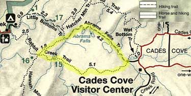
| Trailhead: The Abrams
Falls trailhead is located near the back of the
Cades Cove one-way loop road. Turn
right on the gravel road after crossing the wooden bridge near marker
10. Drive approximately 1/2 mile to the end of this road where you will find a large gravel parking area.
Keep in mind that this road is closed to vehicle traffic Wednesday and
Saturday mornings until 10:00 am.
|
| 0.0 The beginning of this
trail parallels Abrams Creek for much of the distance to the falls.
|
Abrams Falls - 2.7
Longitude: 35° 36.499'N
Latitude: 83° 52.783'W |
| Great Smoky Mountain Maps:
|
Related Links & Resources:
Abrams Falls Geology |