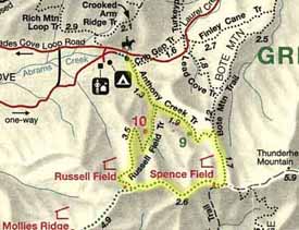
This is a great loop hike in that it can be pretty accommodating with a
weekender's schedule. There are 2 tent sites, 9 & 10, and two shelters,
Russell Field and Spence Field, within the loop hike. The first campsite, #10, is
only about 2 miles from the trailhead so if your getting here in the evening you
can walk to it pretty easily within an hour.
Reservations are required for all backcountry campsites and shelters and can be
made by calling (865) 436-1231.
Cades Cove Ranger Station 0.0 - Hike back down the road to the picnic
area you passed when turning into Cades Coves Ranger Station. The trailhead is
at the very back of the picnic loop road, .
Trailhead .5 Take the Anthony Creek Trail towards Russell Field Shelter
From Spence Field shelter make
your way back to the trail intersection of the AT and the Bote Mountain
trail. From here head north on the Bote Mountain trail for 1.7 miles
Anthony Creek Trail 18.9 -
go left at this trail intersection. After about 1/2 mile you will
see campsite #9 on the left, continue heading down the mountain.
Russell Field Trail
intersection 20.8 - Russell field trail comes in from the left.
Continue down to what turns into a gravel road, passing the horse camp.
The trail emerges into the back of the Cades Cove picnic area. From here
follow the picnic loop road out to the entrance and turn left following
the road towards the ranger station and parking area.
Cades Cove Ranger Station - 13 Ranger Station, small store,
campground, telephones, restrooms.