|
Distance: 23 miles
Difficulty: Moderate
Clingmans Dome Coordinates
Latitude: N 35°33'46"
Longitude: W 83°29'56"
Elevation: 6,643'
Cades Cove Campground Coordinates
Latitude: 35° 36.204'N
Longitude: 83° 46.529'W
Elevation: 1,800
|
|
|
Important!
Clingmans Dome Road is closed in the winter. This is a one-way trip
so you will have to either have two cars or have someone pick you up
at Cades Cove or drop you off at Clingman's Dome. This trip is rated
moderate when traveling from Clingmans to Cades Cove. However, it is
rated strenuous when going from Cades Cove to Clingmans Dome. If you
leave a car at Cades Cove park it in the parking lot across from the ranger
station. If you park at the picnic area don't expect your car to be there when
you get back, it will be towed. |
A seventy mile section
of the Appalachian Trail crosses through the Great Smoky Mountains
National Park, the trail wonders in and out of Tennessee and North
Carolina. This trip covers a 17 mile section of the AT and starts at
Clingmans Dome in the center of the park and you travel southwest on
the AT for most of the trip until the final decent into Cades Cove
Valley. |
|
Map of Appalachian Trail .pdf 1Mb
Smoky Mountain Map -
Trails
|
|
Reservations are required for all backcountry campsites and shelters and can be
made by calling (865) 436-1231. |
|
Clingman's Dome Parking Area 0.0 - Short but strenuous hike from the
parking lot up to the Appalachian Trail. There are two trails leading up to the
AT both are about 1/2 mile long. The paved trail that passes right in front of
the restrooms is a little shorter and closer to the observation tower at the
top. |
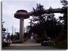
Clingman's Dome -
.5
Highest elevation in the Great Smoky Mountains National Park, also the highest elevation on the Appalachian trail
and 2nd highest mountain east of the Mississippi river. There is an observation
tower open to the public at the top of the mountain. Another interesting thing
about Clingman's Dome is that this is the
western terminus to the
Mountain to Sea trail.
|
Clingman's Dome |
|
Double Spring Gap Shelter - 3.4
Latitude: 35° 33.91'N
Longitude: 83° 32.571'W
Elevation: 5,505' |
|
|
Siler's Bald 4.9 |
Siler's Bald Shelter - 5.0
Latitude: 35° 33.851'N
Longitude: 83° 34.1'W
Elevation: 5,460' |
|
|
The next 34 miles of trail of the trail are the highest of the entire
Appalachian Trail all reaching higher than 5,000 feet. |
|
Buckeye Gap - 7.8 |
|
Sam's Gap - 10.4 |
Derrick Knob Shelter - 10.6
Latitude: 35° 33.974'N
Longitude: 83° 38.514'W
Elevation: 4,890' |
|
|
Sugar Tree Gap - 11.7 |
|
Mineral Gap - 14.1 |
|
Beechnut Gap - 14.8 |
Thunderhead, east peak - 15.1
Pretty steep downhill section through mature hardwoods. |
Rocky Top - 15.7
a great place to take a break or have lunch. Great views of valleys below.
|
Eagle Creek Trail to Spence Field Shelter(4,900'); Bote Mountain Trail - 16.9
|
Spence Field Shelter - 17.2 Latitude: 35° 33.707'N
Longitude: 83° 43.963'W
Elevation: 4,915'It's all down hill from here!
|
|
| From Spence Field shelter make
your way back to the trail intersection of the AT and the Bote Mountain
trail. From here head north on the Bote Mountain trail for 1.7 miles |
| Anthony Creek Trail 18.9 -
go left at this trail intersection. After about 1/2 mile you will
see campsite #9 on the left, continue heading down the mountain. |
| Russell Field Trail
intersection 20.8 - Russell field trail comes in from the left.
Continue down to what turns into a gravel road, passing the horse camp.
The trail emerges into the back of the Cades Cove picnic area. From here
follow the picnic loop road out to the entrance and turn left following
the road towards the ranger station and parking area. |
| |
Cades Cove Ranger Station - 23
Ranger Station, small store,
campground, telephones, restrooms. |
| |
| Great Smoky Mountain Maps:
|
Related Links & Resources:
Abrams Falls Geology |
| |


