Center
Hill Lake
 Center
Hill Lake near Smithville and Cookeville in Middle Tennessee
is a 64 mile long lake with over 400 miles of
shoreline. Center Hill is a great vacation spot for
house boating, skiing, hiking, swimming, picnic,
fishing and much more. Center
Hill Lake near Smithville and Cookeville in Middle Tennessee
is a 64 mile long lake with over 400 miles of
shoreline. Center Hill is a great vacation spot for
house boating, skiing, hiking, swimming, picnic,
fishing and much more.
<Center
Hill Lake> |
Burgess
Falls State Park
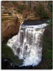 Burgess
Falls State Natural Area is one of the head waters
to Center Hill Lake. Burgess
Falls State Natural Area is one of the head waters
to Center Hill Lake.
<Burgess
Falls State Park>
|


