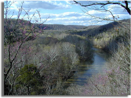
This view is of the Green
River valley from an overlook along Green River
Bluffs Trail near the Visitor Center. Note how the
distant hilltops are all a uniform elevation. The
Green River has incised into the Pennyroal Plateau,
a part of the ancient landscape surface that
extended across the entire midwest region prior to
the periods of glaciation starting in the Pliocene
Epoch (about 5 million years ago). Prior to the
glaciation periods, major drainages in the
Midcontinent drained northward into the Hudson Bay
region. As continental ice sheets formed through the
following Pleistocene Epoch, north-flowing river
drainages were blocked, great lakes formed and
eventually spilled over their divides, diverting the
drainage systems to the Mississippi River valley.
Over time the greater Ohio River system formed with
headwater streams, like the Green River, began
downcarving into their channels. With the passing of
each of the major glaciation periods, the Green
River incised further into its valley. This set the
stage for ongoing cavern development in the Mammoth
Cave region.
|