Southeastern Outdoors Backpacking in the Brooks Range
Southeastern Outdoors
  Home > Public Lands > Rivers > Green River > Green River
Dale Hollow MarinaWeb Site Promotion
   

Green River Ferry

Green River from Trail
USGS Photo ©

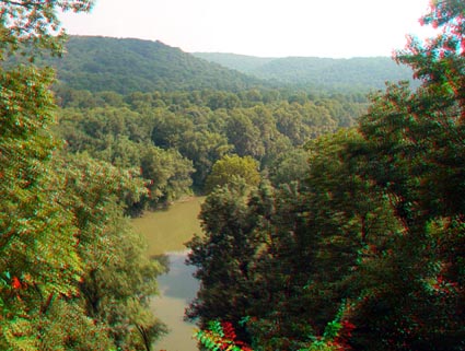
This view is of the Green River Valley from an overlook along the Turnhole Bend Trail. Turnhole Bend is a great incised meander formed by the ongoing downcutting of the Green River into its ancient floodplain. The river elevation here is about 450 feet and the ridge line is about 780 feet, a difference of 330 feet (or about 100 meters). Within this elevation range are five roughly-mappable levels within the cavern system.


Rivers
Green River Main
Kentucky Rivers
Green River Mussel
Hiking forums
Green River
South Fork Map
Paddling Forum
Red-spotted Newt
Sponsor Links
Dale Hollow Marina
Outdoors-411
 
What's This?
Related Links
NPS.gov
BSF Landmarks
Bed & Breakfast Inn
 

Mammoth Cave Books