|
By Craig Ogilvie, travel writer
Arkansas Department of Parks and Tourism
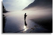 |
| Fly Fishing The White River |
Beginning as a trickle in a rocky ravine deep in the Arkansas Ozarks, the famous White
River slowly gains strength from thousands of natural springs and mountain creeks as it rushes northwest, briefly touches southern Missouri, then descends southward across the eastern
Arkansas Delta to join the mighty Mississippi.
The
million-acre Ozark National Forest gives birth to
several important Arkansas streams, but the White is
queen of all. It has served as a transportation
lifeline and playground since the days when French
fur trappers ventured into the area over two
centuries ago.
Streams bearing names like War Eagle, Buffalo,
Crooked Creek, Kings, North Fork, Little Red, Black
and others contribute to the upper White as it
meanders beneath towering limestone bluffs and along
grassy meadows. The remains of log cabins and
long-abandoned grist mills are reminders of another
age when the Ozarks were among the most isolated
hills in North America.
Early pioneers nudged their flatboats, loaded with
all their worldly goods, up the White to establish
farms among the rich valleys and prairies.
Steamboats followed, pushing river commerce from the
Mississippi to the Missouri state line. By 1905,
trains were steaming along the river's banks from
Batesville to Cotter.
Commercial use of the river during the last century
did no harm to the pristine White. It continued to
serve as a recreational haven for residents and
visitors alike. Smallmouth bass fishing was
legendary and monster catfish were common. Just
prior to World War II, professional outfitters and
fishing guides started appearing on the river.
The forties and fifties brought the greatest changes
ever witnessed in the Ozarks. Under provisions of
the federal Flood Control Act of 1938, the U.S. Army
Corps of Engineers built Norfork and Bull Shoals
dams in Arkansas and Table Rock in Missouri. Almost
overnight, the middle section of the river was
forever changed from a lazy tepid stream to a more
predictable flow of cold water.
Congress authorized the Norfork National Fish
Hatchery in 1955 to help offset the fishery losses
in the area. It was completed in 1957, and one of
the state's most successful industries was soon
underway. Trout marinas and resorts sprouted up at
almost every access between Bull Shoals and Guion.
Johnboat float trips were reinvented for the White
and have become its trademark.
Beaver Lake, on the upper extremes of the river, and
Greers Ferry Lake, on the Little Red River tributary
(completed in the 1960s) are the newest Corps of
Engineers reservoirs in the White River basin. Both
are noted for great fishing, lake recreation and
unique resort communities.
The big lakes, built to harness the powerful White,
have been a sparkplug for Ozark recreation.
Combined, they hold 200,000 surface acres of fresh
water, more than enough to provide water enthusiasts
with a special place for whatever their sport may
be. Bull Shoals, largest in the system with 45,500
acres, has a shoreline of almost 1,000 miles.
Norfork, twenty miles to the east, is smaller at
22,000 acres, but very able at serving visitors.
Ozark lakes boast fine bass fishing, crappie action,
walleye and catfish. Recreational boating, sailing,
scuba diving and other water sports are also
enjoyed.
Trout action can be found in the tailwaters of each
of the massive concrete dams. Flyfishing is popular
below each, but johnboats are still the preferred
mode of travel along the deeper stretches of the
rivers. Norfork and Bull Shoals dams combine to
provide the greatest stretch of cold trout water,
some 125 miles downstream to Guion. The tiny Izard
County community offers the last trout dock on the
upper White.
For years the state trout records were nailed in the
tailwaters of Bull Shoals and Norfork dams. Rainbows
neared the 20-pound mark, cutthroats topped
nine-pounds and a world-record 38-pound, nine-ounce
brown was taken just below Norfork Dam in 1988. The
White River achieved its crown, but the best was yet
to come.
To the south, in the Ozark foothills, the newer
40,000-acre Greers Ferry Lake had been gearing its
tailwaters for a place in fishing history. Its first
state record was a rainbow in 1968, but on May 9,
1992, it was a big brown that stole the headlines.
The late "Rip" Collins of Heber Springs set a new
world record with a 40-pound, four-ounce brown trout
from the Little Red, the last major highland
tributary of the White.
Arkansas incubates its own record-setting catches.
Millions of trout are produced at the Norfork,
Spring River and Greers Ferry hatcheries. And,
warmwater hatcheries are scattered across the state
to produce all varieties of bass, catfish, walleye
and numerous species of panfish.
The Buffalo National Scenic River, perhaps the most
famous tributary of the White, cuts a 150-mile path
through some of the most scenic territory in
mid-America before joining the larger White,
downstream from Cotter. Towering limestone bluffs,
great whitewater canoeing and natural wilderness are
among the wonders of this free-flowing stream.
Highways and bridges offer glimpses of the Buffalo,
but the best way to experience its beauty is by
canoe or raft. Outfitters are plentiful in nearby
towns; and Buffalo Point, north of Marshall,
provides camping, rustic cabins, trails and other
facilities under the auspices of the National Park
Service. Tyler Bend Recreation Area, just off U.S.
65, offers camping facilities and a visitors center.
At Batesville, the White River begins a slower pace
as it winds in snake-like fashion another 300 miles
across the Delta to the Mississippi. Catfish has
been king of the lower White for centuries, but
other species are also plentiful for the taking. Old
river cut-offs and backwaters provide bass and
crappie action. The lower White is also excellent
duck hunting territory; the final stretch of the
river is preserved as a federal wildlife refuge,
covering 155,000 acres.
Conservation is vital for the protection of the
Ozarks' natural resources. Visitors are joining
residents in promoting ecotourism, or unobtrusive
visitation to natural areas, so that future
generations will also have an opportunity to enjoy
Arkansas at its best.
A prime example of federal preservation can be found
near Mountain View, where the U.S. Forest Service
offers guided tours of Blanchard Springs Caverns.
Ranked among the most beautiful limestone caverns in
North America, Blanchard Springs remains a "living"
cave thanks to extraordinary planning and design
more than 25 years ago. Massive rooms,
million-year-old formations and excellent facilities
(including elevators to the cavern floor) make
Blanchard Springs Caverns a favorite of visitors.
And, the caverns also have a river connection.
Sylamore Creek emerges from the caverns and winds
for several miles through the national forest before
entering the White, north of Mountain View. A
popular hiking trail follows the stream much of the
way.
Today, White River is still being discovered by
visitors wanting to experience a wealth of natural
beauty and outdoor fun. It offers world-class
fishing, major recreational lakes, federal and state
parks, canoe streams, spectacular limestone caverns,
award-winning hiking trails, miles of unspoiled
highland forests and plenty of affordable
accommodations.
|