Southeastern Outdoors Backpacking in the Brooks Range
Southeastern Outdoors
  Home > Public Lands > State Parks > Fall Creek Falls
CSP 468Web Site Promotion
   

Fall Creek Falls State Park

Latitude: N 35° 39'57"
Longitude: W 85° 21'21"
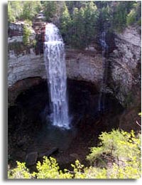
Maps

Fall Creek Falls State Park in middle Tennessee offers a wide variety of activities including hiking, fishing, swimming and lots more. With recent additions the park is over 22,000 acres including numerous waterfalls, gorges, streams and caves.

Activities Include: Hiking, backpacking, fishing, biking, camping, swimming, boating, swimming, horseback riding, picnic areas, and playgrounds, Inn, and cabins.
 
Facilities Include: Inn, and cabins, restaurant, gift Shop, and group lodge.


Directions:

From Nashville: Located approximately 115 miles from Nashville. Take I-40 East to Cookeville. Turn right onto Highway 111 South at Exit 288. Follow signs to the North or South park entrance.

From Atlanta: take I-75 North to Chattanooga, take I-24 toward Nashville, take Hwy 27 North toward Dayton and follow Highway 111 North to the park entrance on the right.
 
 
The swimming pool at the inn, cabins, and group camp are accessible to persons with a disability.
 
Fall Creek Falls
Fall Creek Falls
State Parks
Public Lands
Hiking forums
Rockhouse Falls
Piney Falls
 
Sponsor Links
Dale Hollow Marina
Outdoors-411
 
What's This?
Related Links
National Parks
Big South Fork
 
 
Advertisers
Mountain Boarding

Join the Good Sam Club!