Slipping 178 miles into Arkansas's wilderness, the Ozark Highland
Trail loops across the rugged northern reaches. It begins at Lake
Fort Smith State Park near Fort Smith, then cuts eastward through the
Ozark National Forest, a 1.1-million-acre preserve.
The trail then roams north up to the Gene Rush/Buffalo River Wildlife
Management Area. It travels along the pristine Buffalo River, the
country's first national river, to join the Buffalo River Trail. This
trail continues down river about 13 miles to Tyler Bend Campground.
White rectangular paint blazes mark the way. Blue rectangular paint
blazes mark spur and side trails.
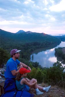
Those who hike the trail or any portion of it will find unspoiled
countryside that looks much the same as it did to pioneer settlers.
They may encounter thick forests of oak, hickory and other hardwoods,
high bluffs, unusual rock outcroppings, and plenty of mountainous
terrain. All along the way are Ozark streams and rivers.
The trail is divided into three sections. The Western Section begins
at the Lake Fort Smith State Park trailhead, continuing on to the
Lick Branch trailhead near the Little Mulberry River.
The Middle Section runs from Lick Branch to the Big Piney trailhead
on the Big Piney River close to Haw Creek Falls Campground. Starting
at the Pig Piney, the Eastern Section meanders through the Ozarks to
the Buffalo National River Boundary near Woolum Campground.
Beginning at Pinnacle Mountain State Park, 15 miles west of Little
Rock, the Ouachita Trail runs 225 miles through the Ouachita National
Forest, a 1.6-million-acre preserve in central and western Arkansas,
to Talimena State Park near Talihina, OK.
This trail crosses high ridges and valleys, with elevations ranging
from 600 to 2,600 feet. It wanders through forests composed of pine
as well as hardwoods, including oaks. The Ouachita Mountains follow
an east-west path; hardwoods cover the moist northern slopes, while
pines forest the southern slopes.
Management of the trail is divided. Pinnacle Mountain State Park
oversees the first 32 miles. The remaining 193 miles come under the
management of the U.S. Forest Service.
Blue vertical rectangles mark the main trail. White blazes mark most
spur and side trails.
Two state parks, Pinnacle and Queen Wilhelmena near Mena, as well as
three National Forest Recreation Areas, including Big Brushy, Iron
Springs, and Lake Sylvia, provide facilities along the trail.
Camping is permitted along both trails anywhere outside of the
recreation areas. One exception is the first (the most western) six
miles of the Ozark National Trail.
Difficulty for both trails ranges from easy to strenuous. Campgrounds
usually are rustic, as are restroom facilities. At some sites,
campers must bring their own water.
Rangers ask campers to follow trail etiquette, which encourages
camping at least 200 feet away from trails and water sources, and
preferably out of sight of the trails. They also encourage campers to
use previous campsites if one is available.
Three maps of the Ozark Highlands Trail, developed by the U.S. Forest
Service, cover the trail. The maps, which indicate topographic
contours, campgrounds, streams, trailhead access points and other
information, can be ordered from the Ozark Interpretive Association,
P.O. Box 1279, Mountain View, AR 72560. Telephone 870-757-2211. The
maps are $3 each plus shipping and handling.
For maps and brochures covering the trail's first six miles, write
the Superintendent, Lake Fort Smith State Park, P.O. Box 4,
Mountainburg, AR 72946. Telephone 501-369-2469. They are also
available at the park's Visitors Center.
A map and trail guides for the first 32 miles of the Ozark Trail can
be picked up at the Pinnacle Mountain State Park Visitors Center, or
by writing to the Superintendent, Pinnacle Mountain State Park, 11901
Pinnacle Valley Road, Roland, AR 72135. There is a $1 fee for the
map.
A map of the other 193 miles can be obtained by writing to: Forest
Supervisor, Ouachita National Forest, P.O. Box 1270, Federal
Building, Hot Springs, AR 71902. Telephone 501-321-5202. The map
costs $3.
Top-rated guides to both trails have been published by Tim Ernst, an
Arkansas author, outdoor photographer, and well-known hiker. Each
guide offers mile-by-mile descriptions of the trails, including
historical facts, scenic and wilderness areas, and information on
campgrounds, shuttle services, and weather. The guides also contain
maps, mileage guides, and elevation profiles.
The Ozark Highlands Trail Guide, Third Edition and The Ouachita Trail
Guide are available for $14.95 each plus $2 for shipping and handling
from: Tim Ernst, 411 Patricia Lane, Fayetteville, AR 72703. Telephone
1-800-838-HIKE. The guides also are available at area bookstores and
sporting goods stores.
In addition to the two National Recreation Trails, Arkansas enjoys
more than 250 hiking trails that total more than 1,500 miles. There
are backpacking trails, horseback trails, and trails just for
walking.
So, take a hike! The trails of Arkansas are waiting.
An "Arkansas Adventure Guide" can be ordered from the Arkansas
Department of Parks and Tourism, One Capitol Mall, Little Rock, AR
72201. Telephone 1-800-NATURAL or visit
www.arkansas.com.
|