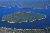
Covered with native trees and topped with massive stone formations,
Sugar Loaf Mountain offers a challenging hike to almost 600 feet
above the lake. Those who reach the summit are rewarded with some of
the most panoramic views found in the Ozarks.
Until the construction of Greers Ferry Lake in the early 1960s, the
mountain stood high and dry, with only spring-fed streams impeding
adventuresome climbers. The South Fork of the Little Red River flowed
nearby before joining the Middle Fork above the "narrows," which
separates Greers Ferry into two sections.
As the lake filled in 1962, Sugar Loaf became an island, under the
domain of the U.S. Army Corps of Engineers. As campgrounds and boat
launch facilities took shape around the lake, the Corps also set
about developing a trail to the top of Sugar Loaf Mountain. On Sept.
2, 1971, it became the first designated National Recreational Trail
in Arkansas.
Hiking to the top of Sugar Loaf has been a pastime since pioneer
days. Group picnics and photography parties at the top continued
right up until lake construction. Sightseers from Little Rock,
Memphis and beyond traveled dusty backroads for a chance to view the
Ozarks from 1,001 feet above sea level.
Today, visitors travel modern highways to one of several marinas in
the region and rent a boat or party barge for the ride out to the
island. (Some marinas offer shuttle service for those not accustomed
to piloting a boat.) Public boat ramps are also available at all
access areas for those using their own boat.
A new Corps of Engineers boat dock welcomes island visitors to the
trailhead on the southeastern shore of the big island. The trail
swings back and forth as hikers near the craggy bluffs that support
the mountain's massive sandstone cap. After millions of years, the
softer stone has weathered away and left an oblong, flat-topped rock
formation high above the treetops. This landmark reminded pioneers of
an inverted loaf pan and resulted in the name. There are several
other Sugar Loaf Mountains in the state, including one along the
Little Red River, near Heber Springs.
Hikers ascending the 1.6-mile trail to the summit, encounter a wide
variety of native plants and wildflowers. In addition to the
hardwoods and pines, the bluffs create withered cedars, contorted by
time, and rare dwarfed English elms standing only two feet tall. Much
of the exposed sandstone is covered by greenish-gray lichen, which
serves as a backdrop for the many species of moss and ferns on the
island. Small animals such as squirrels, raccoons, rabbits, chipmunks
and numerous birds also populate the mountain, which serves as a game
refuge (no hunting allowed).
As the trail reaches the bluffs at the southern end of the "loaf," a
series of wooden stairs aid in the steep climb to the top. There are
several places to enjoy the stunning views along the trail that
traverses the long, narrow rocky-topped mountain. A favorite spot is
the extreme northeast bluff. In addition to spectacular views, the
ancient rock formations alone are worthy of the hike.
Sugar Loaf can be a looping trail for those not wanting to retrace
their footsteps to the top. The original stairway that brought
thousands of hikers up the north rim of the mountain, has been torn
away. "We discovered a natural route down the northeastern face and
have been developing it into a new trail section," says Park Ranger
Bill Allbright, Jr. "The work will be completed this spring."
For those descending via the new pathway, the hike along the
northwestern side of the bluffline can be the most interesting part
of the outing. The trail hugs the rock formations most of the way and
in one or two places visitors actually walk under the massive stone
walls. Plant life along the route can vary from cactus to maidenhair
fern. The loop is completed at the southern end of the bluff and it's
an easy stroll back to the boat dock. Benches are conveniently
located along the route for those wanting additional moments before
returning to the "real world."
Another looping trail has been added in recent times for those who do
not wish to make the hike to the top of Sugar Loaf. The new trail
begins about three-fourths of the way up the main trail. It explores
the base of the bluffs and many of the natural wonders of the island.
All trails are well marked, but visitors should be aware that parts
of the mountaintop pathways are within a few steps of sheer drops of
over 100 feet.
Springtime, when fresh greenery and flowers appear, and autumn with
its vibrant hues, are the most colorful times to visit the island.
But, according to Corps officials, the long days of summer remain the
most popular visitation time on Sugar Loaf. Fresh water, comfortable
clothing and shoes, camera and field glasses are suggested for the
hike.
Guide maps and additional information about Sugar Loaf and the region
are available at the U.S. Army Corps of Engineers/William C. Garner
Visitor Center at the western end of Greers Ferry Dam, north of Heber
Springs, and at many marinas near the island.
|
For questions or comments on the
food list or Backpacking or hiking in general please join us in our hiking discussion forums |