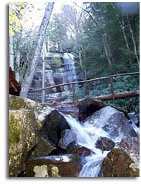
Southeastern Outdoors Mammoth Cave National Park
Southeastern Outdoors
Home > Public Lands > National Parks > Smoky Mountains > Smoky Mountain Waterfalls
Free Shipping on Orders over $50Web Site Promotion
   

Waterfalls of the Smoky Mountains

Rainbow Falls - Smoky Mountains National ParkThe steep terrain and numerous creeks and streams add up to numerous small but picturesque waterfalls within the Great Smoky Mountains. The only waterfalls visible from the road is Meigs Falls which is located 12.9 miles West of the Sugarlands visitor Center.

The remaining Falls all require walking or hiking anywhere from .4 of a mile to eight miles round trip.


Waterfalls Round Trip
Miles
Description Falls Height
Abrams Falls

5

Moderate ~ located off of the Cades Cove loop road

25'

Cataract Falls

1

Easy ~ Start your hike at Sugarlands Visitor Center

80'

Chasteen Creek Falls
4
Moderate ~ Start your hike at Smokemont Campground
20'
Grotto Falls
2.4
Easy to Moderate ~ Near Gatlinburg
25'
Hen Wallow Falls
4.4
Moderate ~ Near Cosby picnic area
45'
Indian Creek Falls
1.6
Easy ~ Deep Creek area, Pass Tom Branch falls on the way
25'
Juney Whank Falls
0.8
Moderate ~ Deep Creek Area
90'
Laurel Falls
2.6
Moderate ~ Between Surgarlands visitor center and Cades Cove
90'
Meigs Falls

0.4

Moderate ~

30'

Mingo Falls
0.4
Moderate ~ Cherokee Indian reservation (Qualla Boundary)
120'
Mouse Creek Falls
4
Moderate ~ Exit 451 from I-40
45'
Rainbow Falls
5.4
Moderate ~ near Gatlinburg, 1500' elevation gain
80'
Ramsay Falls
8.0
Strenuous ~ 10 miles from Gatlinburg, 2,000' elevation gain in 4 miles
100'
Tom Branch Falls
0.5
Easy ~ Deep Creek Area, near Indian Creek Falls
75'
Smoky Mountains
Smoky Mts Main
Tenn Waterfalls
Smoky Mtn. Books
GSM Hiker Dies
Hiking forums
National Parks
Cades Cove
Clingman's Dome
Current Weather
Fall Creek Falls
 
Sponsor Links
Dale Hollow Marina
Outdoors-411

Pigeon Forge Lodging
 
What's This?
Related Links
Tennessee Cabins
Big South Fork
Campgrounds
 
Great Smoky Mountain Books