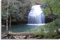
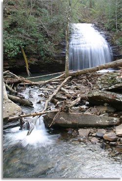
Southeastern Outdoors Backpacking in the Brooks Range
Southeastern Outdoors
  Home > Public Lands > State Parks > Stinging Fork Falls
CSP 468Web Site Promotion
   

Stinging Fork Falls State Natural Area

Stinging Fork Falls Trailhead
Latitude: 35° 42.765'N
Longitude: 84° 55.689'W
Elevation:
 

Stinging Fork FallsStinging Fork Falls State Natural Area near Spring City Tennessee is a 783 acre Class II Natural-Scientific State Natural Area that preserves and protects Stinging Fork Falls and the surrounding water shed.

Stinging Fork Falls - Trail Map


The hiking trail at Stinging Fork Falls about 3 miles round trip if you include the Indian Head Point spur trail. Most of the trail including the Indian Head Point spur is easy, slightly rolling hiking. However, the trail to the falls from the Indian Head split is a moderate to Strenuous 0.4 of a mile hike descending about 200 feet down switch backs, stone steps and one short staircase.


Stinging Fork Falls Pictures

Stinging For Falls PicturesPictures from in and around Stinging Fork Falls State Natural Area near Spring City in Middle Tennessee.   
<Stinging Fork Falls Pictures>  

Cumberland Trail
State Park

Black Mountain - Cumberland TrailTennessee's 300 mile long hiking trail that extends from Chickamauga and Chattanooga National Military Park near Chattanooga, Tennessee to the Cumberland Gap National Park in Kentucky. <Cumberland Trail>


Camping: NO camping at Stinging Fork Falls State Natural Area.


State Parks
Cumberland Trail
State Parks
Public Lands
Hiking forums
Dale Hollow
 
 
Sponsor Links
Dale Hollow Marina
Outdoors-411
 
What's This?
Related Links
National Parks
Big South Fork
Standing Stone
 
Advertisers
Mountain Boarding

Join the Good Sam Club!