| The Cumberland Trail is a
linear state park that stretches from Chickamauga and Chattanooga
National Military Park near Chattanooga Tennessee to the Cumberland
Gap National Park in Kentucky. The following links will take you to
additional information about Cumberland Trail State Park including
pictures, GPS coordinates, maps and more. |
About the Cumberland Trail
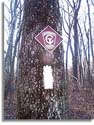 Pictures
from on and around Cumberland Trail in middle Tennessee. Pictures
from on and around Cumberland Trail in middle Tennessee.
<Cumberland Trail Info.>
|
Cumberland Trail Pictures
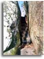 Pictures
from on and around Cumberland Trail in middle Tennessee. Pictures
from on and around Cumberland Trail in middle Tennessee.
<Cumberland Trail
Pictures>
|
| |
CT - Grassy Cove to Black Mountain
 Trail
section description, pictures from on and around Cumberland Trail
from Black Mountain to Grassy Cove in middle Tennessee. Trail
section description, pictures from on and around Cumberland Trail
from Black Mountain to Grassy Cove in middle Tennessee.
<Grassy Cove to Black Mtn>
|
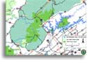
Cumberland Trail Maps
 Trail
section description, pictures from on and around Cumberland Trail
from Black Mountain to Grassy Cove in middle Tennessee. Trail
section description, pictures from on and around Cumberland Trail
from Black Mountain to Grassy Cove in middle Tennessee.
<Cumberland Trail Maps>
|
| |
Cumberland Gap NHP
Cumberland
Gap National historic Park in Kentucky is the northern terminus for
the Cumberland Trail State Park in Tennessee.
<Cumberland
Gap NHP>
|
CT -
Obed River Section
Cumberland
Trail State Park
section descriptions, pictures, GPS coordinates and more from in and around the Obed
Wild & Scenic River section of the Cumberland Trail in middle Tennessee.
<Obed W&S River Section>
|
| |
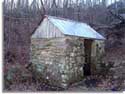
Black Mountain Pictures
Pictures
from on and around Black Mountain in Cumberland county Tennessee. Photos
of spring house, overlooks, rocks, climbing and more. The
Cumberland Trail crosses Black Mountain
near Grassy Cove.
<Black Mountain Pictures>
|
Black Mountain
 Pictures
of rock climbing, and rock formations in and around Black Mountain in middle Tennessee. Pictures
of rock climbing, and rock formations in and around Black Mountain in middle Tennessee.
<Black Mountain>
|
| |
Catoosa WMA
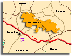 Over 80,000
acres of public access property in Cumberland and Morgan counties.
Hunting, hiking, backpacking, kayaking and more <Catoosa
WMA> Over 80,000
acres of public access property in Cumberland and Morgan counties.
Hunting, hiking, backpacking, kayaking and more <Catoosa
WMA>
|
Sundquist WMA
 Sundquist Wildlife Management Area (WMA) is located in Campbell and Anderson
Counties northwest of Knoxville Tennessee. Sundquist Wildlife Management Area (WMA) is located in Campbell and Anderson
Counties northwest of Knoxville Tennessee.
<Sundquist WMA>
|
| |
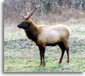
Royal Blue WMA
 View
or print a map of middle Tennessee's elk reintroduction
zone View
or print a map of middle Tennessee's elk reintroduction
zone
<Royal
Blue WMA>
|
Chickamauga and Chattanooga
NMP
 Chickamauga
and Chattanooga National Military Park in north Georgia is the
southern terminus for the Cumberland Trail State Park. Chickamauga
and Chattanooga National Military Park in north Georgia is the
southern terminus for the Cumberland Trail State Park.
<Chickamauga
and Chattanooga NMP>
|
| |
Tennessee State Parks
Cumberland
Trail State Park is one of more than 50 state parks in Tennessee.
Southeastern Outdoors.com has a growing database of information about,
Tennessee's parks including pictures, GPS coordinates, maps and more.
<Tennessee State Parks>
|
Stinging Fork Falls State Natural Area
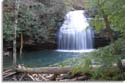 Stinging
Fork Falls State Natural Area is a 783 acre park
with waterfalls and hiking trail near Spring City
in Tennessee. Soon to be part of the
Cumberland Trail Stinging
Fork Falls State Natural Area is a 783 acre park
with waterfalls and hiking trail near Spring City
in Tennessee. Soon to be part of the
Cumberland Trail
<Stinging
Fork Falls Natural Area>
|
| |
Obed Wild & Scenic River
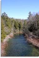 Hiking,
climbing and paddling information from in and around Obed National
Wild & Scenic River near Crossville and Wartburg, Tennessee.
Information includes maps, pictures, GPS waypoints and more
<Obed
Wild & Scenic River > Hiking,
climbing and paddling information from in and around Obed National
Wild & Scenic River near Crossville and Wartburg, Tennessee.
Information includes maps, pictures, GPS waypoints and more
<Obed
Wild & Scenic River >
|
|
| |
| |
|
Related Links & Sources
• Cumberland
Trail Conference
•
Cumberland Trail Map
•
Black Mountain Article
•
Birds & Butterflies along the Cumberland Trail
•
Obed River section report
•
Chickamauga and Chattanooga
National Military Park
•
•
|
|
For questions or comments on the
gear list or Backpacking please join us in our hiking discussion forums |


