|
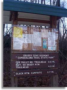
The Grassy Cove section of the
Cumberland Trail is a 12.6 mile
section between Black
Mountain and the Jewett Road Trailhead.
This description of the Grassy Cove section is divided into three
parts; Black Mountain trailhead to Cox Valley Rd. trailhead (3.8
miles), Cox Valley trailhead to Brady Mountain trailhead (.7 mile),
and Brady Mountain trailhead to Jewett Road trailhead (7.8 miles).
Take exit #329 off of I-40 Crab Orchard 10 miles east of Crossville Tennessee. Go
south for 1.6 miles to Owl Roost Road, turn left. Continue up the
mountain 2.5 miles to a parking area on the right at the base of
large tower. Camping is permitted only in the established
campsite about .7 of a mile from the Black Mountain Trailhead. Camping is free but registration is required
for camping at the Black Mountain campsite. You can
register to camp on-line.
 Black Mountain Trailhead -
This first section of trail is from Black Mtn Trailhead 3.8 miles to
Cox Valley Rd trailhead. Black Mountain Trailhead -
This first section of trail is from Black Mtn Trailhead 3.8 miles to
Cox Valley Rd trailhead.
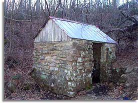
The trail is located 50 yards south of the parking area near the
covered spring house, a small rock building with a natural feed water
supply. Walk through the parking lot past the orange barriers. Cross
the road following the narrow, paved, cross road for about another 30
yards, you will see a sign.
The water at the
springhouse is has always seemed to be a good water supply. I have been
going here for 25+ years and I don't remember it ever being dry, Of
course it should to be treated, filtered or boiled.
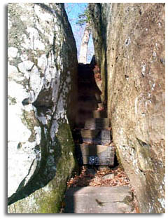
 From
the spring house go up the steps near the door to the Cumberland
Trail (CT). From
the spring house go up the steps near the door to the Cumberland
Trail (CT).
For the next .2 the trail gently climbs to the top of Black
Mountain where you will notice a side trail to the left that takes
you out to a great view of
Grassy Cove Karst National Landmark.
After viewing Grassy Cove return to the Cumberland Trail and turn
left of course. Follow the trail for another.2 of a mile to where the
trail heads down hill through a
natural stone hallway (pictures below).
 Make
your way through a garden of giant stones walking at the feet of
giant boulders. If your day hiking this section plan to spend a
little time wandering around and on the boulders, they are
incredible. Make
your way through a garden of giant stones walking at the feet of
giant boulders. If your day hiking this section plan to spend a
little time wandering around and on the boulders, they are
incredible.
From the boulders follow the CT downhill for another .4 of a mile
to the Black Mountain Campsite (35° 51.864 N - 84° 53.897 W).
From the campsite continue to follow the Cumberland Trail down
Black Mtn. after about 1 mile the CT merges with an ATV trail and
continues downhill for about .3 mile to Windless Cave (35° 52.106N -
84° 54.534W).
Unfortunately Windless Cave is where the Black Mtn to Cox Valley
section currently "officially" ends.
A verbal agreement had been reached with the landowner to cross
his property to Cox Valley via and existing logging rd/ATV trail.
However, the property changed hands before a written agreement was
signed. Some hikers and ATV users continue to use the trail between
Windless Cave and Cox Valley Trailhead (35° 52.754N - 84° 55.742W).
|


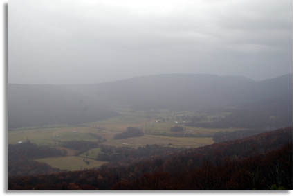 Brady
Bluff offers a fantastic
view of the
Brady
Bluff offers a fantastic
view of the 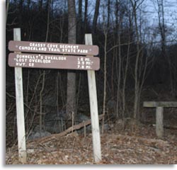 Jewett Rd. Trailhead